

Tutorial 1 - Information about postcodes
Follow this example in order to learn how to download metadata for postcodes. You will need a file of postcodes in plain text format in order to use this function.
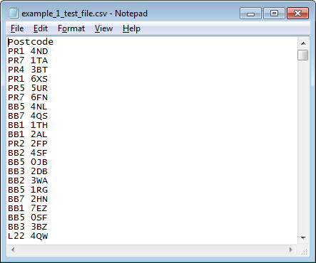
Example Test File
example_1_test_file.csv
The Problem
A university administrator wishes to obtain deprivation scores and eastings/northings in order to create a thematic map of student home addresses in England for Widening Participation work. The administrator has a text file containing the home postcodes (Example Test File example_1_test_file.csv is available above, right-click and choose 'Save target as...' or 'Save link as...') to which they need to add a 2015 IMD Score and eastings and northings in order to be able to plot them on a GIS map.
Further information concerning deprivation scores can be found in the documentation section.
Step 1: Starting out
Access GeoConvert by using the following link: geoconvert.ukdataservice.ac.uk.
- Click the Start GeoConvert button.
- Ensure the Information about Postcodes radio button is selected, and then click the 'Next' button at the bottom of the screen.
- The only option now is 2011 UK Census postcode lookup, so click 'Next' again.
Stage 2: Choose Metadata
Metadata is data that describes and characterises the geographical zones under investigation. We have also added some additional items of data that are most often requested by researchers and students.
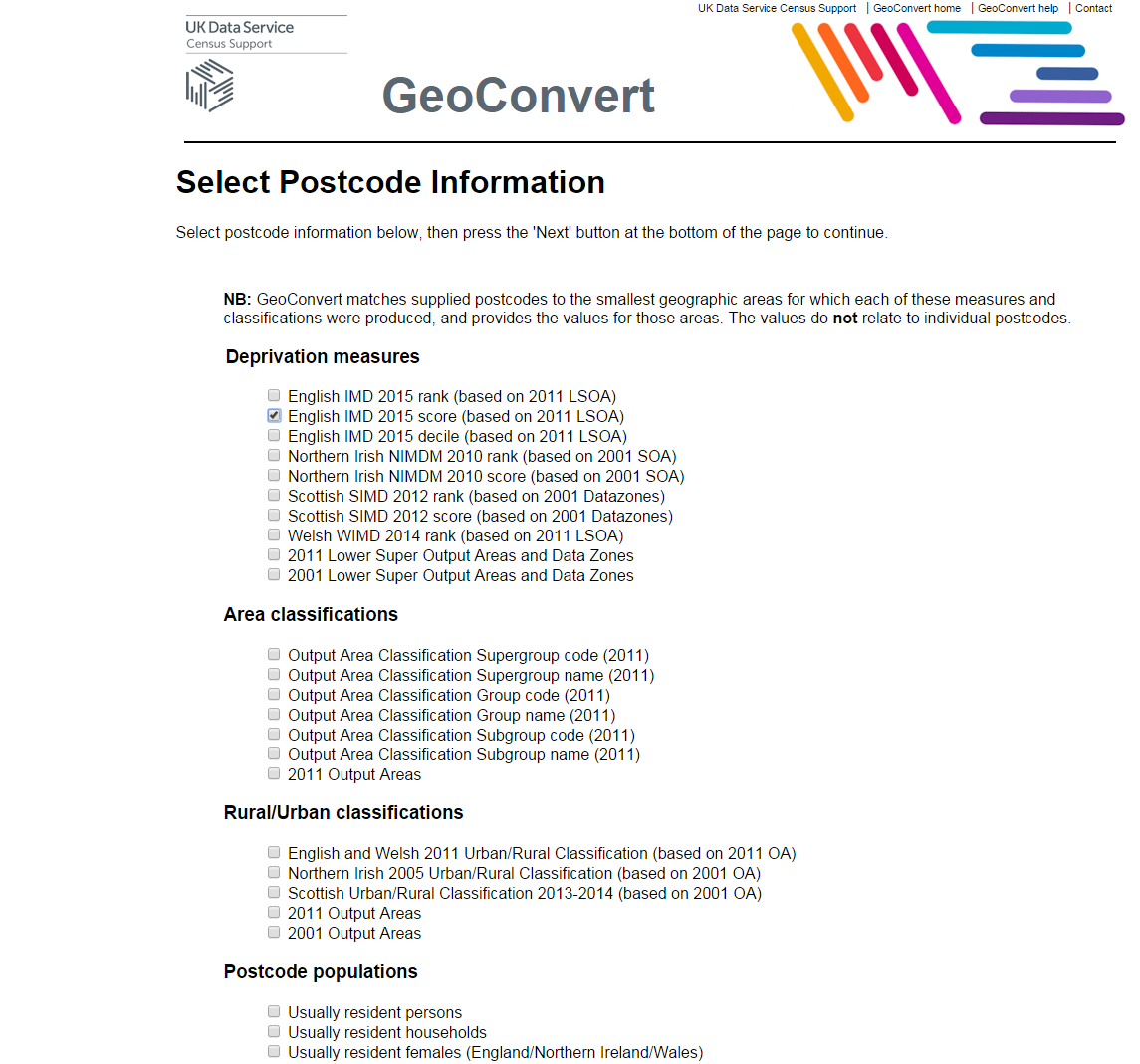
Click in the checkbox for:
- English IMD 2015 score (based on 2011 LSOA)
- Postcode easting (Longitude/WGS84/EPSG: 4327)
- Postcode northing (Latitude/WGS84/EPSG: 4327)
Then press the 'Next' button.
Step 3: Enter postcodes
Download our test file of postcodes example_1_test_file.csv to your local computer; right-click on the link and select 'Save link as...' or 'Save target as...' (depending on your browser). From there, you can then upload it to GeoConvert.
We have a file of postcodes we want to add the metadata to, so we will choose the options to upload a file.
Our postcode file is just a simple text file of one column, the postcodes, one per line. We have a header record, this is the first line of the file which is used to name the columns. We do not have any column delimiter characters, as we do not yet have any other columns to delimit, however, once we add the metadata we will want to use commas. By using commas to delimit our columns we are creating what is called a 'comma-separated values' file or CSV. CSV files are commonly used by statistical and spreadsheet programs such as Excel. You should have no problem importing and exporting your data in CSV format.
If you are using your own file, please note it must be saved as plain text (e.g. .txt or .csv). An .xlsx file will not work.
Select 'comma' from the 'Column Delimiter Character' section and 'yes' from the 'Header Record' section.
In the 'Input File Section', click on the 'Choose file...' button, then find the test postcode file 'example_1_test_file.csv' from where you saved it on your computer. Click the 'Open' button in the 'Choose file' dialogue box once you have selected the correct file.
To submit the postcode file for processing, click on the 'Next' button.
Step 4: Show Results
The output from the GeoConvert Metadata function takes two forms: that where the postcodes can be matched and that where no match can be found. By splitting up the matched and unmatched results you can easily keep track of your good and bad input postcodes.
Click on the link to the 'Unmatched Rows' file, this will either launch the file into a spreadsheet window or allow you to save it to your computer to open it in a software package of your own choosing. Once you have the file open, you will see it contains a number of entries for postcodes that do not exist and the 'input row' (their position in the input file in case you have a huge input file and wish to go back and amend it). You can close this window once you have finished with it.
Now open the 'Postcode Metadata' file by clicking on its link. Again, this will either launch in a spreadsheet browser window or allow you to save it and open in your own software package. Once you have opened the file, you will see something similar to the screenshot below:
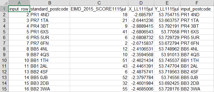
The header row contains the names of the variables in each column:
- input_row: this is the position of the postcode in the original input file.
- standard_postcode: the standard name of the matched postcode.
- EIMD_2015_SCORE1115jul: the IMD 2015 score.
- X_LL1115jul: Easting.
- Y_LL1115jul: Northing.
- input_postcode: the original input postcode.
A 'Metadata Codebook' is supplied on the results page, which contains explanations of the metadata variables that have been selected. Details of most options can be found in the Documentation section.
You now have metadata linked to the postcodes in the sample file. You can either save the file using your spreadsheet save command or close the window.